Methane is a potent greenhouse gas that can leak from oil and gas wells, pipelines and landfills. Satellites can spot the releases fast enough to get them fixed and help protect the climate.
California’s Central Valley has some of the worst fine particle pollution in the U.S. due to farming and other sources.
David McNew/Getty Images
Reducing particle pollution can save thousands of lives, but states need more data to inform better controls. An atmospheric scientist explains what data and actions are needed.
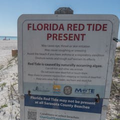
Warning sign at Lido Key Beach in Sarasota, Fla., March 15, 2023, during a toxic algae bloom.
Jesus Olarte/AFP via Getty Images
The tiny organisms that cause harmful blooms of algae can have a big impact on your trip to the shore. A toxicologist explains what causes these events and how to keep people and pets safe.
Over 8,000 satellites are orbiting Earth today, capturing images like this, of the Louisiana coast.
NASA Earth Observatory
Automated content moderation using algorithms are quick and cheaper. But, they’re not necessarily better than human beings. They are prone to errors and can impose bias in a systemic scale.
A volunteer looks for waterbirds at Point Reyes National Seashore in California during the National Audubon Society’s annual Christmas Bird Count.
Kerry W/Flickr
COVID-19 kept many scientists from doing field research in 2020, which means that important records will have data gaps. But volunteers are helping to plug some of those holes.
Rapid loss of species like these Spix’s macaws, considered extinct in the wild, may represent the sixth mass extinction in Earth’s history.
PATRICK PLEUL/DPA/AFP via Getty Images
A new plan targets areas around the world that can store carbon and protect large numbers of species. It calls for preserving these lands, working with Indigenous peoples and connecting wild areas.
Fresno, California and the surrounding San Joaquin Valley have some of the nation’s highest levels of fine particle air pollution.
AP Photo/Gary Kazanjian
A new study shows that while fine particle air pollution has declined nationwide over the past 40 years, the health and environmental benefits haven’t been shared evenly.
The Australian National University is turning to digital proctoring to replace the role of a walking invigilator. But who watches the proctor, what are the risks, and what data will be collected?
‘Smart cities’, featuring networks of automatic lights, video cameras and environmental sensors, have been hailed as an enhancement to urban life. But they are also tools of surveillance and control.
An aerial photo of Borneo shows deforestation and patches of remaining forest.
Greg Asner
A new study lays out a road map for protecting and restoring 50% of Earth’s surface, targeted to preserve biodiversity and maximize natural removal of carbon from the atmosphere.
There are 130 billion gallons of water in Wisconsin’s Lake Mendota, and now, trillions of spiny water fleas.
Corey Coyle/Wikimedia
It’s cheaper to prevent biological invasions than to react after they happen. But it’s hard to detect invaders while there are still just a few of them. Knowing when and where to look can help.
Drones are low cost and easy to operate.
Shutterstock/Halfpoint
Red tide and a blue-green algae outbreak are fouling hundreds of miles of coast, killing fish and driving tourists away from beaches. Some of the causes are natural, but human actions play a big role.
Each wolf calls with its own ‘voice.’
Angela Dassow
Tracking wild animals can provide lots of valuable data. New research suggests audio recordings of wild wolves can replace the typical radio collars, which can be expensive and intrusive.
The Victorian mountain ash forest has been severely affected by fires and logging. To determine the actual health of the forest, we need to look at the quality, not just the quantity of what remains.
Graeme/flickr
In the aftermath of fires or logging, conservation needs to focus on recovering the health of the remaining vegetation, not just the size of the forest or woodland.